
Fire Notice (current as of Thursday, July 23rd at 09:30 AM)

Acres: 2,310– Containment: 0% – Detection: 07/09/26 – Cause: Lightning – Personnel: 374
Location: 7 miles northwest of Lake City, Colorado
Operational Update: Weather hindered operations on Wednesday. Chippers worked along the control line between Little Elk Trailhead and High Bridge Gulch. Mastication neared completion along the dozer line close to Road 868 and the Stock Driveway. The secondary control line around Lake City was completed.
Today: Masticators will work along the dozer line between the Stock Driveway and Road 868 and along Nellie Creek Road. Chipping will take place along Road 868. On the secondary control line around Lake City, snags will be removed and chipped. Suppression repair on control lines, including constructing water bars for erosion, will begin.
Roads: There is still a reduced speed limit on Highway 149 and County Road 20 due to increased firefighter traffic. The Alpine Loop is open and there are no closures on County Road 30 (Cinnamon Pass) where trails and campgrounds remain open.
Weather: There is a potential for heavy rainfall with thunderstorms today. Valley temperatures 76°-79° and 64°-67° in the fire footprint, with winds 5-10 mph, and afternoon gusts 15-20 mph
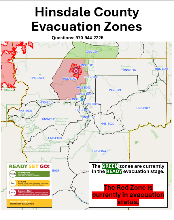
Evacuations: The Hinsdale County Sheriff’s Office has issued the following changes to evacuation zones on the Elk Fire.
Effective 9:00 a.m. Thursday, July 23, Zone 5 will move from Get Set (yellow) to Get Ready (green) and zone 3 will remain in Get Ready as well. In all other zones (4, 6, 12, 13, 14 and 16) evacuation statuses have been rescinded. Residents are encouraged to remain alert and aware of their surroundings as conditions can rapidly change. Current evacuation information is available at the links below:
Hinsdale County: https;//hinsdalecounty.colorado.gov
Gunnison County: https://emergency.gunnisoncounty.org/elk-fire. To sign up and receive emergency alerts for Gunnison County visit: https://emergency.gunnisoncounty.org/preparedness/sign-up/
Closures: The National Forest has implemented an area closure west of Highway 149 and north of County Road 20 in Hinsdale and Gunnison Counties. For further information visit: https://www.fs.usda.gov/r02/gmug/alerts
The Bureau of Land Management (BLM) has implemented a temporary emergency closure for public lands, roads and trails north of County Road 20 (Engineer Pass). The closure includes Nellie Creek, the Uncompahgre Trailhead and the upper portion of County Road 24 (North Henson) from Capitol City to the Wetterhorn and Matterhorn areas. For further information visit: https://www.blm.gov/programs/public-safety-and-fire/fire-and-aviation/regional-information/colorado/southwest-district
Road Closures: Forest Service Road 7868 (Alpine Road) remains closed. Some public maps display the route as Road 868. Forest Service roads 877 (Nellie Creek) and 870 (Matterhorn Trailheads) to the north are closed.
No Fly Zone: A Temporary Flight Restriction (TFR) over the area remains in effect. Flying drones near the fire is prohibited and can interfere with firefighting aircraft, potentially grounding aerial suppression operations. http://knowbeforeyoufly.org.
Elk Fire Information
970-299-5357
Website: https://inciweb.wildfire.gov/incident-information/cogmf-elk-fire
Facebook: https://www.facebook.com/profile.php?id=6159205073757