
Fire Notice (current as of Thursday, July 29th at 1:30 PM)
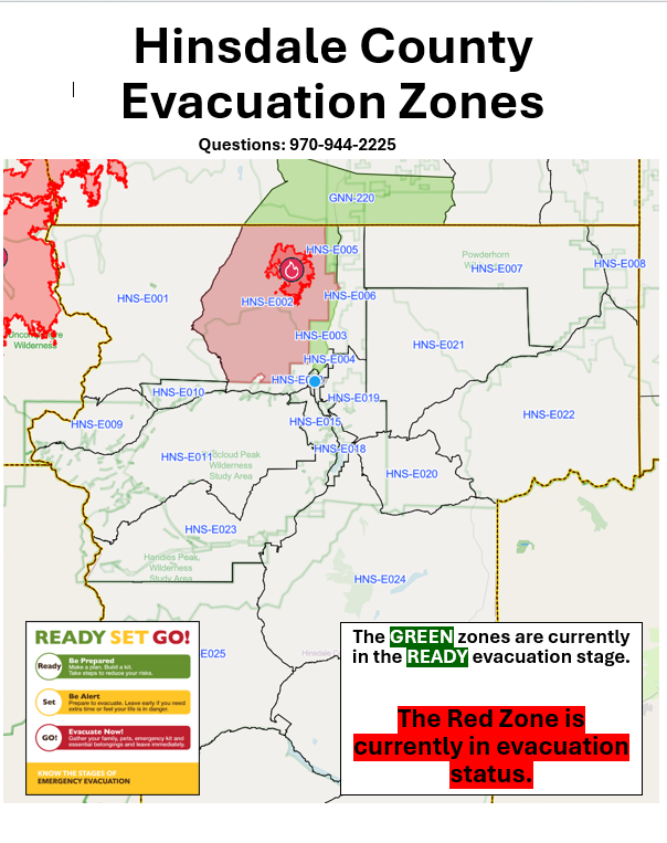


Grand Mesa, Uncompahgre and Gunnison (GMUG) National Forest are opening Nellie Creek Road and Uncompahgre Trail Head starting July 29.
The forest service has reduced the closures in the vicinity of the Elk Fire to allow the opening of Nellie Creek Road – National Forest Service Road (NFSR) 7877, Nellie Creek Trailhead, Uncompahgre Peak Trail – National Forest System Trail (NFST) 9239 and Uncompahgre Peak. The Nellie Creek road is located approximately three miles from Lake City on CR 20. Lands on either side of the of the road and trail remain closed, including any other trails that leave from Nellie Creek or the Uncompahgre trail.
Trailheads and sites that will remain closed in Hinsdale County include Crystal Larson Trailhead, Big Blue Trailhead, Fall Creek Trailhead, Independence Trailhead and Little Elk Trailhead as well as those in Gunnison County including Big Blue Campground, Alpine Ranger Station, Alpine Trailhead, Alpine/Little Cimarron Trailhead and Big Blue Campground.
Roads and Trails in Hinsdale and Gunnison counties that will remain closed include 7236 Crystal‑Larson, 7867 Alpine Plateau, 7867.2A West Fork, 7867.2C Ridgestock, 7867.3A Little Blue, 7867.3B Willow Creek, 7867.3C Long Draw, 7867.3H Alpine Plateau Spur 3H, 7867.3J Alpine Plateau Spur 3J, 7867.4A Long Draw Camping Road, 7868 Alpine, 7868 1A, 1B, 1C, 1D, and 2A, 7868.1E Big Blue CG Road, 864 Little Cimarron, 864.4A Little Cimarron Trailhead Road, 864.4C Johnson Park, 864.4C1 Johnson Park Spur 1, 864.C5 Little Cimarron Spur C5, 870 North Fork Henson Creek and 870.2A Matterhorn Creek. Trails include High Mesa (6133), Matterhorn (6135), Middle Canyon (6136), Alpine (6225), Wetterhorn Basin (6226), Little Cimarron (6229), Failes Creek (6230), Big Park (6234), Firebox (6245), Little Cimarron East (6246), Sheep Mountain (6253), Saddle (9140), Alpine (9225), Alpine Guard Station Spur (9225.1A), Fall Creek (9231), Big Blue Creek (9232), Ridge Stock Driveway (9233), Ridge Stock Driveway Spur (9233.1B), Independence Gulch (9234), Independence Bypass (9234.1A), Crystal Lake (9235), View (9235.1A), Larson Lakes (9236), Larson Lakes Cutoff (9236.3A), El Paso Creek (9238), Thompson Lake (9241), Matterhorn TH Spur (9242), Little Elk (9244), Matterhorn Cutoff (9245) and Wetterhorn Peak (9256).
The change in closures goes into effect July 29 at 12:01 a.m.